Costa Rica Geography & Ecology

Our country's geographical location constitutes a biological land bridge for plant and animal species. The narrow territory flanked by the Caribbean Sea and the Pacific Ocean creates a passage for North and South American plants and wildlife, in addition to a large number has resulted in over 25% of the land being protected under some sort of management category, such a National Parks, Biological Reserves, and National Wildlife Refuges.
One of the great attractions is its climate. The nice temperature enjoyed throughout the year has been a factor in the peaceful life led by inhabitants, and allows tourists to explore and venture with total ease. Additionally, the smallness of the land makes it easy to go from the Pacific to the Caribbean in less than one day.
Costa Rica is bordered to the north by Nicaragua, to the northeast by the Caribbean Sea, to the southeast by Panama, and to the west and southwest by the Pacific Ocean.
Area: 51,100 Km2
Maximum Length: 464 Km from Sapoa River to Burica Point
Minimum Length: 119 Km from Tuba to mouth of Colorado River
Maximum width: 259 km from Cape Santa Elena to mouth of Colorado River
Highest Mountain: Chirripo (altitude 3,820 m above sea level)
Largest Crater: Poas Volcano (one of the largest craters in the world, (1.3 km diameter)
The Capital: San Jose.
Administrative Division: 7 Provinces (San José, Alajuela, Cartago, Heredia, Guanacaste, Puntarenas y Limón).
Total Populations: 4.248.481 (2004) (50.86 % men / 49.14% women)


 Geography & Ecology
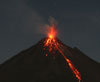 Costa Rica History
 Quick Facts about Costa Rica
 Expeditions & Trekking Trips
 Adventure Trips
 Private Custom Adventure Trips
 Tours & Attractions
 Adventure Training
 Adventure Consultants